TEMPO.CO, Jakarta - The Geological Agency recorded Mount Semeru experiencing eruptive earthquakes up to 583 times during the period of May 23-31, 2026. The Acting Head of the Geological Agency, Lana Saria, noted the high seismic activity of the volcano.
According to data from the Geological Agency received by Tempo on Wednesday, June 3, 2026, the local seismicity was dominated by eruptive or explosive earthquakes, deep volcanic earthquakes, rockfall earthquakes, gas explosion earthquakes, tremors, and distant tectonic earthquakes.
Instrumental observations conducted at the Semeru Volcano Observatory Post (PGA) logged 583 eruptive earthquakes, 20 rockfall earthquakes, 2 deep volcanic earthquakes, 108 gas explosion earthquakes, 24 harmonic tremors, and 43 distant tectonic earthquakes.
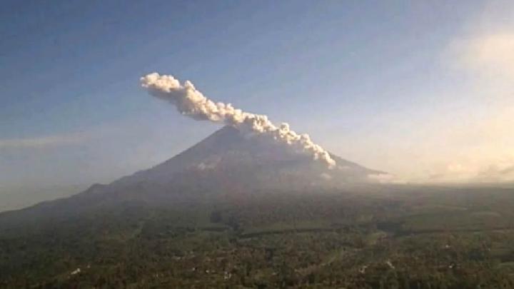
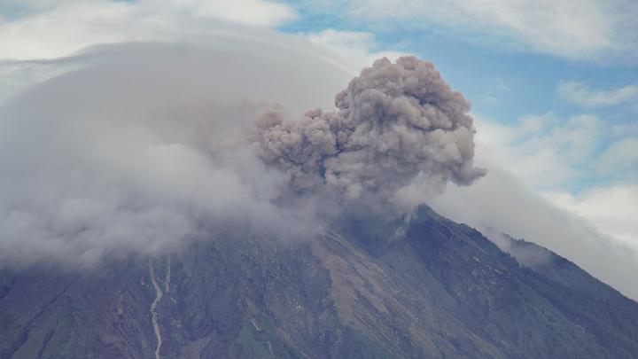
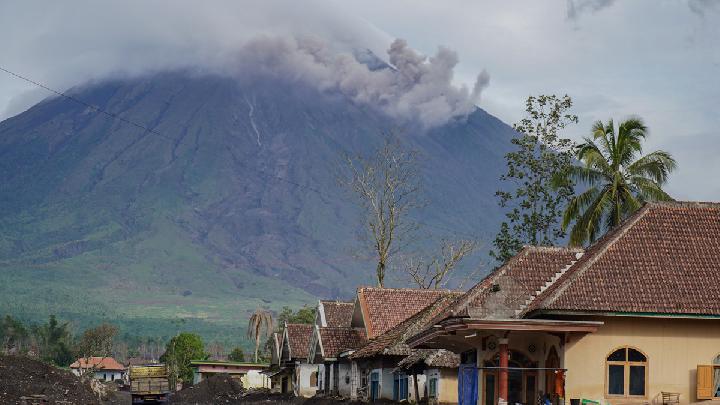
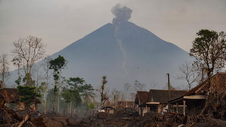
Meanwhile, visual observations over the same period noted a white-to-gray eruptive column drifting southwest and northeast, reaching heights of 400 to 1,500 meters above the summit.
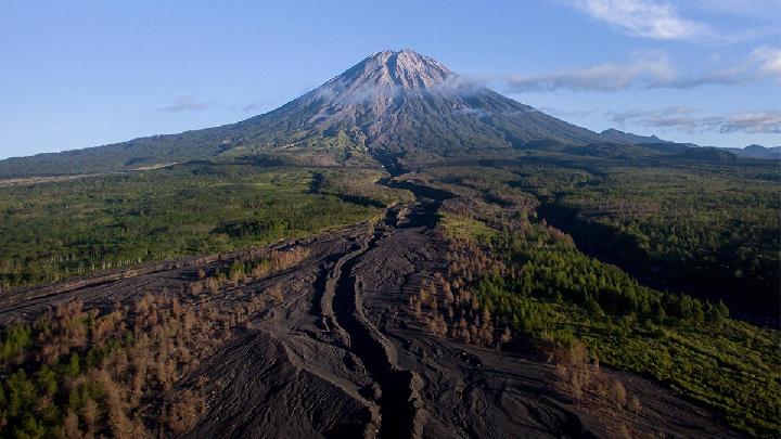
In addition, white and gray crater smoke of thin-to-medium intensity was observed rising 100 to 300 meters from the peak. Lava avalanches were also spotted traveling 500 to 1,000 meters in a southeastern direction, alongside pyroclastic flows (hot avalanche clouds) that charted a sliding distance of 2,000 to 2,500 meters from the summit toward the southeast.
Lana clarified that the ongoing pyroclastic flows are primarily a response from unstable surface material. "And they are not due to active magmatic processes," Lana Saria stated in a written release on Wednesday, June 3, 2026.
She further noted that deformation monitoring results throughout the May 23–31 window displayed a relatively stable pattern. "This indicates the absence of any accelerating pressure buildup inside the volcano," she explained.
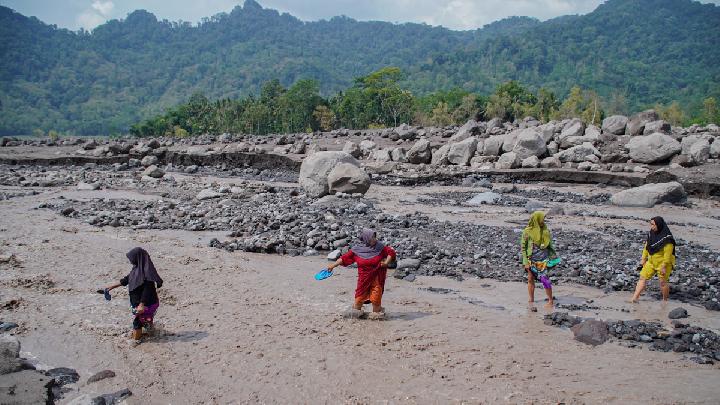
Nevertheless, Lana urged the public to remain vigilant against potential pyroclastic flows, lava collapses, and cold lava mudflows (lahars) along nearby river channels and valleys. "In the southeast sector, along the Besuk Kobokan riverbed within a 13-kilometer radius of the eruption center, there remains a persistent threat of expanding pyroclastic and lahar flows," she warned.
Furthermore, areas within 500 meters of the riverbanks along Besuk Kobokan up to a distance of 17 kilometers from the peak face similar risks of expanding flows. "The explosive eruption hazard zone is restricted to within 5 kilometers of the crater, where there is a risk of being struck by airborne volcanic debris," Lana said.
Despite the activity, she confirmed that Mount Semeru's official status is currently holding steady at Alert Level III, or 'Watch'.
A report from the PGA Post on Mount Sawur, located in Sumber Wuluh Village, Candipuro District, Lumajang Regency, noted a fresh eruption on Wednesday morning at 08:29 a.m. WIB, with an ash column rising approximately 800 meters above the peak, or roughly 4,476 meters above sea level. The visible ash column appeared white to gray with moderate intensity, drifting toward the south. This marked the fourth distinct eruption reported since 06:00 a.m. WIB that morning.
Read: Three Volcanoes Erupt Overnight Across Indonesia
Click here to get the latest news updates from Tempo on Google News
Three Volcanoes Erupt Overnight Across Indonesia
5 hari lalu
According to PVMBG, the volcanic eruptions occurred a little before and after midnigt into Friday, May 29, 2026.
Mount Semeru Erupts Sunday Morning, Sends Ash 900 Meters Into the Sky
31 hari lalu
Mount Semeru, located on the border of Lumajang and Malang Regencies, East Java, Indonesia, erupted with a plume reaching 900 meters above the summit.
Mount Semeru Erupts Twice This Morning, Ash Column Reaches 1.2 Km
48 hari lalu
Residents are advised to be wary of the potential for pyroclastic flows, lava avalanches, along the river/valley flowing from the peak of Mount Semeru.
Mount Semeru Eruption Sends 4.5km of Pyroclastic Flow
56 hari lalu
A column of ash from the eruption of Mount Semeru on Tuesday evening, April 7, 2026, reached a height of two kilometers above the peak.
Mount Semeru Erupts Twice This Morning, Alert Maintained at Level III
27 Maret 2026
The volcanic activity alert status of Mount Semeru remains at Level III.
Geological Agency Warns of Repeated Hot Clouds at Mount Semeru
15 Februari 2026
The Indonesian Geological Agency assesses that Mount Semeru's volcanic activity remains high.
Mount Semeru Erupts Twice After Midnight, Alert Status Maintained
5 Februari 2026
Mount Semeru erupted again early Thursday, February 5, 2026, at 12:13 a.m. Western Indonesian Time (WIB).
Mount Semeru Erupts Seven Times From Dawn to Morning
4 Februari 2026
Mount Semeru's consecutive eruptions were reported from after dawn until this morning, Wednesday, February 4, 2026.
Mount Semeru Emits Hot Clouds for Two Days, Alert Level Remains High
16 Januari 2026
During the period of January 7-14, 2026, Mount Semeru's volcanic activity remains high with frequent occurrences of pyroclastic flows.
Volcanic Activity at Indonesia's Mount Semeru Remains High
15 Januari 2026
A total of 36 eruption earthquakes were recorded at Mount Semeru from early Thursday to 06:00 AM local time.