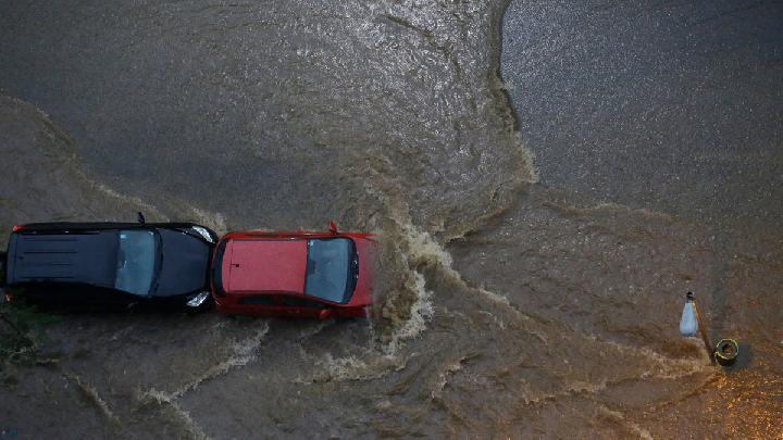
TEMPO.CO, Jakarta - Persistent rain in parts of Indonesia, even as the Meteorology, Climatology, and Geophysics Agency (BMKG) warns of a potentially long dry season and possible El Niño conditions, has raised public questions about why wet weather is still occurring.
For many Indonesians, the continued rainfall appears to contradict forecasts of a prolonged dry season, especially amid growing discussion of a possible strong El Niño, sometimes referred to in public discourse as “El Niño Godzilla.”
According to Sonni Setiawan, a lecturer at the Department of Geophysics and Meteorology at IPB University, the phenomenon is not unusual and remains consistent with Indonesia’s current seasonal cycle.
“This is still a transition period, and the start of the dry season is not uniform across all regions of Indonesia,” Sonni said in a written statement on Wednesday, April 8, 2026.
Why rain can still fall during the transition season
Sonni said ongoing rainfall does not necessarily mean BMKG’s forecast is inaccurate. Indonesia is currently in a seasonal transition period, when weather patterns can vary significantly between regions.
In practical terms, this means some areas may continue to experience moderate to heavy rainfall, while others begin shifting into drier conditions earlier.
He said indications of a longer dry season are still visible, particularly from rising sea surface temperatures in the central and eastern tropical Pacific Ocean.
“The sea surface temperature in the central and eastern Pacific tropical regions continues to rise,” he said.
That increase is considered an early signal of El Niño, a climate pattern that typically reduces rainfall in Indonesia and can intensify dry-season conditions.
BMKG’s dry season forecast remains in place
Sonni said the latest weather patterns do not undermine expectations of a prolonged dry season this year.
According to him, the dry season in 2026 is still expected to be longer than usual, potentially lasting around six months in some regions.
He also said the onset of the dry season may come earlier than normal, especially in Java, where the dry season typically begins around July.
“The beginning of the dry season is earlier than usual,” he said.
He explained that this shift is linked to warming in the Pacific, which tends to suppress cloud formation over Indonesia.
“The increase in sea surface temperatures has an impact on reducing cloud formation in Indonesia,” Sonni said.
In other words, while rain can still occur now, especially during the transition phase, the broader climate signals still point to drier conditions ahead.
What is El Niño, and why does it matter for Indonesia?
Sonni said El Niño and its opposite phase, La Niña, are part of large-scale ocean-atmosphere interactions that affect weather across the tropics.
These events are tied to changes in the Walker Circulation, an east-west atmospheric circulation system over the tropical Pacific.
“The Walker Circulation is the east-west airflow, where air rises over continents and descends over oceans,” he said.
When El Niño develops, this circulation weakens or shifts, often reducing rainfall over Indonesia and increasing the risk of drought, crop disruption, water shortages, and forest fires.
El Niño and La Niña generally occur in cycles every four to five years, although their strength and timing vary.
What does “El Niño Godzilla” mean?
Sonni also addressed the widely discussed term “El Niño Godzilla,” which is often used informally to describe an exceptionally strong or “super” El Niño.
He said the term refers to a very intense El Niño event, stronger than typical episodes.
“El Niño Godzilla refers to a super El Niño, in which sea surface temperatures in the Pacific can rise by about 2.5 degrees Celsius or more above normal compared with typical El Niño conditions,” he said.
He added that such extreme events can last for around one year on average.
Historically, similar super El Niño events occurred in 1982, 1997, and 2015, each associated with severe global impacts, including extreme drought and large-scale forest fires.
However, Sonni said current conditions do not yet point to a super El Niño.
“To be honest, its strength is still weak to moderate,” he said.
Could 2026 still see a stronger El Niño?
In his analysis, Sonni also linked the possibility of a stronger El Niño to sunspot activity, or dark spots on the Sun associated with solar cycles.
Based on his review of 35 years of rainfall data from 72 stations in Java, along with sunspot data and Niño 3.4 data—a key index used to monitor El Niño—he said there may be a relationship between solar activity and El Niño intensity.
He said previous “El Niño Godzilla” events tended to occur after a sunspot maximum, and noted that the sunspot peak in 2025 could potentially be followed by a stronger El Niño in 2026.
Still, Sonni cautioned that this line of research remains preliminary.
He said broader spatial coverage and longer-term datasets are still needed to confirm the relationship scientifically.
For now, Sonni urged the public to continue following official BMKG updates and to understand that Indonesia’s current weather conditions are part of a complex seasonal transition, not necessarily a contradiction of dry-season forecasts.
Read: UN Chief Welcomes Two-Week Ceasefire Between Iran, US
Click here to get the latest news updates from Tempo on Google News